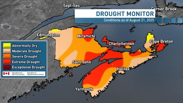
A monthly update of the Canadian Drought Monitor shows many parts of the Atlantic region in the red, representing “extreme drought,” including almost the entire province of Prince Edward Island.
Agriculture and Agri-Food Canada posted the updated map, based on data from Aug. 31, this week.
As for the Atlantic region, only parts of Labrador showed normal conditions, with areas on the island of Newfoundland ranging from “abnormally dry” to “exceptional drought,” especially on parts of the Avalon Peninsula stricken by forest fires this summer.
Most of New Brunswick and Nova Scotia ranged from “moderate drought” to “severe drought” conditions.
“At the end of the month, 72 per cent of the Atlantic Region was classified as abnormally dry (D0) or in moderate to extreme drought (D1 to D3), including 100 per cent of the region’s agricultural landscape,” text accompanying the map said.
The text also said that New Brunswick, Prince Edward Island, and southwestern Nova Scotia got less than a quarter of their normal precipitation for the month of August. As well:
- Parts of the Annapolis Valley had their driest August on record at under 15 mm.
- Charlottetown had its third driest August, while Saint John had its fourth driest August.
- Fredericton, Moncton, and Summerside areas had their fifth driest August on record.
“Fire bans and restrictions on land use, water conservation, and water delivery were established to reduce impacts,” the Canadian Drought Monitor text said.
“Low water conditions prompted industrial restrictions in forested areas, while below-normal rivers and reservoirs continue to raise concerns over water supply… Water shortages affected municipalities and groundwater-reliant residents, leading to conservation notices and mandatory restrictions in several communities. Crop losses have been reported as irrigation ponds and wells dry up.”

The lack of rainfall has also left most of the region with tinder-dry forests and grasslands, even in historically damp eastern Newfoundland.
“On the Avalon Peninsula, wildfires forced evacuations near St. John’s, and the town of Sunnyside declared a state of emergency after reservoirs ran dry, requiring manual pumping to maintain supply,” the text said.
As for Prince Edward Island, the monitor showed that drought intensified rapidly compared to the previous month, “with the entire province now in extreme drought (D3), a 2- to 3-drought-class jump from July.”

Potato producers across P.E.I. say this summer has been among the worst in recent memory for drought-like conditions. Even growers with irrigation and drought-resistant varieties are predicting smaller crops. CBC’s Nancy Russell and drone operator Aaron Adetuyi headed out to the countryside for a first-hand look.
“When we look at the summer months of June, July, and August, most of P.E.I. saw around half of normal rainfall over that three-month period, so it is no surprise that P.E.I. is currently experiencing severe to extreme drought conditions,” said CBC Prince Edward Island meteorologist Jay Scotland.
August rainfall on the Island ranged from only 10 to 35 millimetres in most places.
Normal rainfall for the month at the Charlottetown Airport recording station would be 96.3 millimetres, as calculated by Environment Canada for the period from 1991-2020. That station got 12 millimetres in August.
The three-month summer rainfall total at Charlottetown Airport was 159 millimetres, only about 60 per cent the normal amount. Elsewhere on the Island, volunteer station totals ranged from 120 millimetres to 190 millimetres, which is 50 to 70 per cent of the normal 230-270 millimetre range for the Island.
“It is important to note that summer rainfall is often convective in nature with highly localized thunderstorms occurring, so this ranking using Charlottetown Airport data does not reflect all areas on P.E.I.,” Scotland said.
